El Niño and La Niña: The Ocean's Mood Swings That Change the World
Picture this: farmers in Australia scan a cloudless sky for rain that never comes, while on the other side of the world, villages in Peru are wading through floodwater that arrived without warning. Half a globe away, a hurricane season that should have been brutal ends quietly. None of this is random. None of it is bad luck. All of it traces back to the temperature of the Pacific Ocean — and two climate patterns that have shaped life on Earth for thousands of years.
El Niño and La Niña are those patterns. They are the two opposite phases of a natural climate cycle called the El Niño-Southern Oscillation, or ENSO. You have probably heard the names — they come up every time there is an unusual monsoon, a strange hurricane season, or a drought somewhere that was not supposed to be dry. But what are they, really? How do they work? And why does a shift in sea surface temperature thousands of kilometres away end up deciding whether your region has floods or fires?
This article answers all of that — in plain language, without the jargon, and with the full picture of what makes El Niño and La Niña two of the most important climate forces on the planet.
First, What Does 'Normal' Look Like in the Pacific?
Before you can understand El Niño and La Niña, you need a baseline. Under normal, neutral conditions, the tropical Pacific Ocean behaves in a fairly predictable way.
Strong trade winds blow steadily from east to west along the equator. These winds act like a giant conveyor belt, pushing warm surface water westward toward Australia, Indonesia, and the Philippines. As that warm water piles up in the western Pacific, it raises sea levels there by about half a metre compared to the eastern side. Meanwhile, off the coast of South America, cooler water wells up from the deep ocean to replace what the winds have pushed away. This upwelling brings nutrients to the surface, which is why the waters off Peru and Ecuador are some of the most productive fishing grounds on Earth.
That is the normal. Warm in the west, cooler in the east, steady winds in between. When this balance is disturbed — either weakened or strengthened — you get El Niño or La Niña.
What Is El Niño and How Does It Form?
El Niño begins when the trade winds weaken. Scientists are still working to fully understand what triggers this weakening, but once it starts, a self-reinforcing feedback loop takes over.
With weaker winds, the warm water that had been pushed westward starts to drift back toward the central and eastern Pacific. As it does, sea surface temperatures in that region climb — sometimes 2°C, sometimes as much as 4°C above the long-term average. That may not sound like a lot, but in terms of the energy it injects into the atmosphere, it is transformative.
The warmer ocean heats the air above it. That warmer air rises, reducing atmospheric pressure over the eastern Pacific and further weakening the trade winds. Weaker winds allow more warm water to accumulate, which warms the air more, which weakens the winds further. The cycle feeds itself. This is what meteorologists mean when they talk about ocean-atmosphere coupling — the ocean and the atmosphere are locked in a conversation, and during El Niño, that conversation escalates.
In simple terms: El Niño = trade winds weaken → warm water drifts east → Pacific heats up → global weather patterns shift.
The name ‘El Niño’ — meaning ‘the little boy’ or ‘the Christ child’ in Spanish — was coined by Peruvian fishermen centuries ago. They noticed that every few years, around Christmas, the waters off their coast turned unusually warm and the fish disappeared. The name stuck, and it eventually found its way into the scientific literature.
What Is La Niña and How Is It Different?
La Niña is El Niño’s opposite — and in many ways, its equal in terms of global impact.
During La Niña, the trade winds strengthen beyond their normal intensity. They push even more warm water than usual into the western Pacific, and the upwelling of cold water off South America intensifies. The central and eastern Pacific cools below average, sometimes dramatically. The pattern of heat and moisture in the atmosphere reorganises itself all over again — but in the opposite direction.
La Niña — meaning ‘the little girl’ — was named later as the recognised counterpart to El Niño. Together, they form the two extremes of the ENSO cycle. Events typically last between 9 and 18 months, and they tend to occur irregularly every 2 to 7 years. Sometimes La Niña follows an El Niño directly. Sometimes there is a neutral period in between. Occasionally, a La Niña event will persist for two consecutive years — what climate scientists call a double-dip La Niña — with compounding effects on the regions it touches.
What El Niño Does to the World's Weather
The effects of El Niño ripple outward from the Pacific through a process called teleconnection — the way changes in one part of the atmosphere trigger changes in distant parts of the globe. Here is what that looks like in practice.
Drought and Fire
El Niño suppresses rainfall across Australia, Indonesia, the Philippines, India, and parts of East Africa. During strong events, this can mean prolonged drought, failed harvests, and devastating wildfires. The 1997–98 El Niño — one of the most powerful of the 20th century — triggered fires across Indonesia so extensive that the smoke blanketed most of Southeast Asia for months, causing health crises and grounding flights across the region.
Flooding in South America
While El Niño dries out the western Pacific and South Asia, it drenches the western coast of South America. Peru and Ecuador can experience catastrophic flooding during strong events, washing away roads, destroying crops, and displacing entire communities. The same 1997–98 event that caused fires in Indonesia caused floods in Peru so severe they were described as once-in-a-generation disasters.
A Quieter Atlantic Hurricane Season
Here is one of El Niño’s more counterintuitive effects: it tends to suppress Atlantic hurricane activity. By increasing wind shear — the difference in wind speed and direction at different altitudes — over the Atlantic, El Niño prevents storm systems from organising into powerful hurricanes. For people living along the US Gulf Coast and the Caribbean, an El Niño year can mean a somewhat calmer hurricane season, though it is never a guarantee.
Warmer Global Temperatures
El Niño releases an enormous amount of heat stored in the ocean into the atmosphere, which pushes global average temperatures upward. Several of the hottest years on record have followed strong El Niño events. The record-breaking global temperatures of 2016 came in the wake of a powerful El Niño. The 2023–24 El Niño, declared one of the five strongest ever recorded by the World Meteorological Organisation, similarly contributed to what became the hottest year in recorded human history.
What La Niña Does to the World's Weather
La Niña tends to reverse many of El Niño’s effects — but it brings its own distinct hazards that are no less serious.
Heavy Rainfall and Flooding
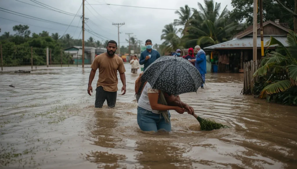
Where El Niño brings drought to Australia, La Niña brings floods. Eastern Australia, South and Southeast Asia, and parts of East Africa receive above-average rainfall during La Niña years, sometimes catastrophically so. The 2010–11 La Niña caused Queensland, Australia to flood so extensively that an area larger than France and Germany combined was underwater. The 2022 Pakistan floods — which killed over 1,700 people and affected more than 33 million — occurred during a La Niña event and were among the most destructive in the country’s history.
Drought in the Americas
The flip side of La Niña’s generosity with rainfall elsewhere is dryness in the southern United States, Central America, and parts of South America. Texas, the US Southwest, and portions of the Caribbean often face drought conditions during La Niña years, stressing water supplies, harming agriculture, and increasing wildfire risk. The 2011 drought in Texas — one of the worst in the state’s recorded history — occurred during a strong La Niña.
More Active Atlantic Hurricane Seasons
By reducing wind shear over the Atlantic, La Niña creates ideal conditions for hurricanes to form, strengthen, and persist. Several of the most destructive Atlantic hurricane seasons on record have coincided with La Niña conditions. For Caribbean and Gulf Coast communities, La Niña years typically call for heightened hurricane preparedness from the very start of the season.
El Niño vs. La Niña: The Key Differences at a Glance
Both phenomena are driven by the same underlying ocean-atmosphere system, but they pull the global climate in opposite directions:
- Sea temperatures: El Niño warms the central/eastern Pacific; La Niña cools it.
- Trade winds: El Niño weakens them; La Niña strengthens them.
- Australia & South Asia: Drought under El Niño; flooding under La Niña.
- Western South America: Flooding under El Niño; drier conditions under La Niña.
- Atlantic hurricanes: Suppressed by El Niño; enhanced by La Niña.
- Global temperatures: Pushed higher by El Niño; slightly cooled by La Niña.
Why This Matters More Than Ever
El Niño and La Niña have always been part of Earth’s climate system. Ancient civilisations from the Inca in South America to farming communities in South Asia learned to read the signs and adapt their lives accordingly. But the stakes today are different — and higher.
As greenhouse gas emissions warm the planet’s baseline temperature, El Niño and La Niña events are playing out in an already hotter world. The background warmth amplifies the extremes. Droughts linked to El Niño become more intense. Floods associated with La Niña occur against already elevated sea levels, making them more damaging. The 2023–24 El Niño did not cause the record global temperatures of that year on its own — climate change had already loaded the dice.
Research published in Nature Climate Change suggests that extreme El Niño and La Niña events could become twice as frequent by the end of this century under high-emission scenarios. That would mean more frequent agricultural disruptions, more intense storm seasons, more unpredictable water supplies — challenges that will fall hardest on the communities with the fewest resources to cope.
On the more hopeful side, advances in climate science have dramatically improved our ability to forecast these events. A network of ocean buoys called the Tropical Atmosphere Ocean (TAO) array spans the equatorial Pacific, continuously measuring temperatures, currents, and winds. This data feeds into computer models that can now predict the onset of El Niño or La Niña with reasonable accuracy 6 to 9 months in advance. That kind of early warning gives farmers time to switch crops, governments time to pre-position aid, and water managers time to build up reserves. Knowledge, in this case, is quite literally a lifesaving tool.
Conclusion
El Niño and La Niña are not just weather events — they are the ocean speaking. They are the Pacific’s way of redistributing the enormous amount of energy the planet absorbs from the sun, and in doing so, they touch the lives of billions of people who may never have heard those names.
Whether it is the farmer in Maharashtra watching the monsoon arrive late, the fisherman in Lima watching the sea go empty, or the family in Queensland watching water creep under their door — the thread connecting these experiences runs through the temperature of the Pacific Ocean and the strength of the trade winds.
Understanding El Niño and La Niña will not stop them from happening. But it can help us prepare, adapt, and respond — and in a world where the climate is becoming less predictable by the decade, that understanding is one of the most valuable things we have.